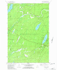
1981 Map of Golden Lake
USGS Topo · Published 1982About this map
The Ottawa National Forest dominates this section of Michigan's Upper Peninsula, where the landscape is defined by a dense network of glacial lakes and river systems. Along the eastern shore of Golden Lake, the University of Michigan Forestry Camp stands as a significant institutional landmark, highlighting the region's long-standing importance for silviculture and forest management research. The Chicago and North Western railroad corridor cuts through the northern half of the map, following the path of the South Branch Paint River past the small settlement of Elmwood. Further south, the terrain is shaped by Cooks Run and a cluster of smaller bodies of water, including Fourth Lake, Sago Lake, and Ely Lake. The mapping captures a period of established recreational and scientific use, evidenced by the Golden Lake Recreation Area and various boat ramps on James Lake and Tamarack Lake.
Find a feature on this map
22 named features on this map. Tap any name to fly to it.
Don’t see what you’re looking for? This feature index may not catch every label — zoom into the map to look around manually.
Map Details
Editions of this 1981 Golden Lake Map
This is the sole edition of this map. No revisions or reprints were ever made.
Other maps of this area

1938 · Phelps
USGS Topo · 1:48,000

1950 · Phelps
USGS Topo · 1:48,000

1952 · Watersmeet
USGS Topo · 1:62,500

1954 · Kenton
USGS Topo · 1:62,500

1956 · Beechwood
USGS Topo · 1:62,500

1956 · Phelps
USGS Topo · 1:62,500

1958 · Iron River
USGS Topo · 1:250,000

1960 · Iron River
USGS Topo · 1:250,000

1961 · Iron River
USGS Topo · 1:250,000

1967 · Iron River
USGS Topo · 1:250,000