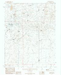
1987 Map of Goldfield
USGS Topo · Published 1988About this map
Goldfield and the nearby settlement of Diamondfield anchor this high-desert mining landscape during the late 20th century. The terrain is defined by an intensive history of extraction, visible through the density of mine shafts and prospects scattered across Vindicator Mountain, Banner Mountain, and Florence Hill. The industrial footprint is further evidenced by the Columbia mine area and its associated tailings, while the Old Railroad Grade and Telephone Line trace the corridors of 19th-century infrastructure that once served these remote camps.
Find a feature on this map
33 named features on this map. Tap any name to fly to it.
Don’t see what you’re looking for? This feature index may not catch every label — zoom into the map to look around manually.
Map Details
Editions of this 1987 Goldfield Map
This is the sole edition of this map. No revisions or reprints were ever made.
Other maps of this area

1908 · Lida
USGS Topo · 1:250,000

1913 · Lida
USGS Topo · 1:250,000

1945 · Goldfield
USGS Topo · 1:125,000

1952 · Mud Lake
USGS Topo · 1:62,500

1952 · Goldfield
USGS Topo · 1:62,500

1954 · Goldfield
USGS Topo · 1:250,000

1955 · Goldfield
USGS Topo · 1:250,000

1958 · Goldfield
USGS Topo · 1:250,000

1962 · Goldfield
USGS Topo · 1:250,000
1970 · Montezuma Peak SE
USGS Topo · 1:24,000