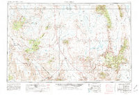
1954 Map of Goldfield
USGS Topo · Published 1981About this map
The Montezuma Range and Goldfield Hills anchor this high-desert survey, where the mining legacy of the early twentieth century is preserved in the form of Numerous mines and an extensive old railroad grade. In this mid-century period, large swaths of the terrain have been designated as the Nellis Air Force Range and the Tonopah Test Range, reflecting the Cold War era's shifting use of the Great Basin landscape. To the south, the map reaches the northern edge of Death Valley National Monument, including the site of Scottys Castle. Transportation and water remain central themes, evidenced by the Southern Pacific Railroad in the east and various remote outposts like Bonnie Claire and Lida. The vast basins of Sarcobatus Flat and Stonewall Flat illustrate the drainage patterns characteristic of the region's internal hydrology.
Find a feature on this map
108 named features on this map. Tap any name to fly to it.
Don’t see what you’re looking for? This feature index may not catch every label — zoom into the map to look around manually.
Map Details
Editions of this 1954 Goldfield Map
3 editions found

Other maps of this area

1898 · Silver Peak
USGS Topo · 1:125,000

1900 · Silver Peak
USGS Topo · 1:125,000

1907 · Mt. Whitney
USGS Topo · 1:125,000

1907 · Tonopah
USGS Topo · 1:250,000

1907 · Las Vegas
USGS Topo · 1:250,000

1908 · Kawich
USGS Topo · 1:250,000

1908 · Lida
USGS Topo · 1:250,000

1908 · Furnace Creek
USGS Topo · 1:250,000

1908 · Las Vegas
USGS Topo · 1:250,000

1908 · Tonopah
USGS Topo · 1:250,000