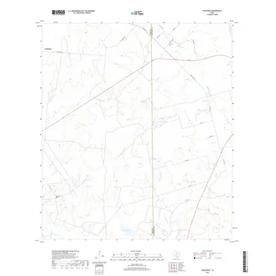
2019 Map of Goldfinch
USGS Topo · Published 2019About this map
Goldfinch anchors this 2019 survey of the South Texas landscape, where the border between Frio and Atascosa counties is defined by a north-south divide. The terrain is marked by the Marshall Hills to the west and a complex drainage system that feeds into the San Miguel Cr. Water management is central to this rural area, evidenced by features such as the County Line Tank and Miracle Lake. Small local cemeteries like Luna Cem provide valuable touchpoints for genealogists researching family ties in this region of ranching and light agriculture. The map details an extensive network of county roads including Davis Switch Rd and FM 140, which navigate around seasonal watercourses such as Chiltipin Cr and Liveoak Creek.
Find a feature on this map
28 named features on this map. Tap any name to fly to it.
Don’t see what you’re looking for? This feature index may not catch every label — zoom into the map to look around manually.
Map Details
Editions of this 2019 Goldfinch Map
This is the sole edition of this map. No revisions or reprints were ever made.
Other maps of this area

1934 · Schattel
USGS Topo · 1:62,500

1953 · Crystal City
USGS Topo · 1:250,000

1955 · Crystal City
USGS Topo · 1:250,000

1956 · Jourdanton
USGS Topo · 1:62,500

1956 · Hindes
USGS Topo · 1:62,500

1956 · Franklin Settlement
USGS Topo · 1:62,500

1961 · Crystal City
USGS Topo · 1:250,000

1968 · Crystal City
USGS Topo · 1:250,000
1968 · Dobrowolski
USGS Topo · 1:24,000
1968 · Schattel
USGS Topo · 1:24,000