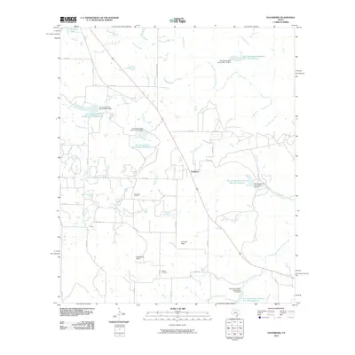
2010 Map of Goldsboro
USGS Topo · Published 2010About this map
Jim Ned Creek and its various tributaries, including South Fork Jim Ned Creek and Red Bank Creek, dominate this Coleman County landscape. The area is defined by a series of mid-century water management projects, evidenced by numerous Soil Conservation Service Site 19 Reservoir and Soil Conservation Service Site 20 Reservoir installations. The small settlement of Goldsboro sits along the primary north-south corridor, while the Hull-Dobbs Oil Field indicates the importance of petroleum extraction to the local economy. Prominent elevations like Jim Ned Peak and Chandlers Peak provide distinct landmarks above the drainage basins. Rural life is further marked by the Midway Cemetery and the tiny locale of Tokeen, connected by an extensive network of county roads such as Abilene-Coleman Rd.
Find a feature on this map
49 named features on this map. Tap any name to fly to it.
Don’t see what you’re looking for? This feature index may not catch every label — zoom into the map to look around manually.
Map Details
Editions of this 2010 Goldsboro Map
This is the sole edition of this map. No revisions or reprints were ever made.
Other maps of this area

1890 · Abilene
USGS Topo · 1:125,000

1892 · Abilene
USGS Topo · 1:125,000

1892 · Ballinger
USGS Topo · 1:125,000

1954 · Brownwood
USGS Topo · 1:250,000

1954 · Abilene
USGS Topo · 1:250,000

1958 · Abilene
USGS Topo · 1:250,000

1967 · Novice West
USGS Topo · 1:24,000
1967 · Novice East
USGS Topo · 1:24,000

1967 · Tuscola
USGS Topo · 1:24,000
1967 · McEwen Draw
USGS Topo · 1:24,000