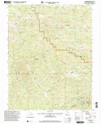
2002 Map of Goldstrike
USGS Topo · Published 2005About this map
Gold mining operations and high desert peaks define this 2002 update of the Washington County landscape, where the Goldstrike site sits near the confluence of Beaver Dam Fork and Quail Gulch. The terrain is marked by significant mineral exploration, from the Emma Mine on Mineral Mountain to the Bull Run Mine in the southeast corner. These prospects are scattered among deep drainages like Butcher Knife Canyon and Black Canyon, illustrating the geological complexity that drew prospectors to this corner of the Dixie National Forest.
Find a feature on this map
44 named features on this map. Tap any name to fly to it.
Don’t see what you’re looking for? This feature index may not catch every label — zoom into the map to look around manually.
Map Details
Editions of this 2002 Goldstrike Map
This is the sole edition of this map. No revisions or reprints were ever made.
Other maps of this area

1885 · St. George
USGS Topo · 1:250,000

1885 · Pioche
USGS Topo · 1:250,000

1886 · Pioche
USGS Topo · 1:250,000

1891 · St. George
USGS Topo · 1:250,000

1953 · Cedar City
USGS Topo · 1:250,000

1954 · Caliente
USGS Topo · 1:250,000

1954 · Gunlock
USGS Topo · 1:24,000

1958 · Cedar City
USGS Topo · 1:250,000

1958 · Docs Pass
USGS Topo · 1:24,000

1959 · Caliente
USGS Topo · 1:250,000