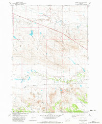
1982 Map of Gomer Draw
USGS Topo · Published 1982About this map
Willow Creek meanders through the northern reaches of this landscape on the Montana-Wyoming border, marking a drainage system defined by deep coulees and seasonal draws. This early 1980s topography reflects an era of resource extraction and rural infrastructure, most notably evidenced by several large Clay Pits scattered across the southern terrain. The area's logistical network is anchored by the long, straight traverse of Ridge Road, which runs parallel to a regional Pipeline, signaling the industrial utility of this sparsely settled corner of Carter County. Smaller watercourses like Thompson Creek and Gomer Draw carve through the breaks, while isolated Landing Strips emphasize the vast distances and aerial reliance of local ranching or industrial operations near the state line.
Find a feature on this map
14 named features on this map. Tap any name to fly to it.
Don’t see what you’re looking for? This feature index may not catch every label — zoom into the map to look around manually.
Map Details
Editions of this 1982 Gomer Draw Map
This is the sole edition of this map. No revisions or reprints were ever made.
Other maps of this area

1901 · Aladdin
USGS Topo · 1:125,000

1903 · Aladdin
USGS Topo · 1:125,000

1905 · Devils Tower
USGS Topo · 1:125,000

1954 · Ekalaka
USGS Topo · 1:250,000

1954 · Gillette
USGS Topo · 1:250,000

1955 · Gillette
USGS Topo · 1:250,000

1956 · Ekalaka
USGS Topo · 1:250,000

1957 · Mona
USGS Topo · 1:62,500

1957 · Seely
USGS Topo · 1:62,500

1958 · Gillette
USGS Topo · 1:250,000