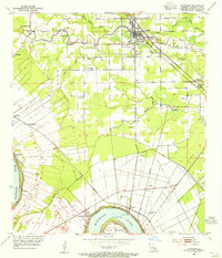
1953 Map of Gonzales
USGS Topo · Published 1955About this map
Gonzales serves as a central hub in this mid-century survey of Ascension Parish, where the local economy follows the winding paths of bayous and rails. The settlement of Burnside sits at a prominent bend in the Mississippi River near Point Houmas, marking a critical transition point from river transport to the interior. Extensive drainage networks, including the Panama Canal and the Bayou Conway, define the low-lying terrain, supporting rural communities like Marchlandville and Brittany.
Find a feature on this map
40 named features on this map. Tap any name to fly to it.
Don’t see what you’re looking for? This feature index may not catch every label — zoom into the map to look around manually.
Map Details
Editions of this 1953 Gonzales Map
This is the sole edition of this map. No revisions or reprints were ever made.
Other maps of this area

1892 · Donaldsonville
USGS Topo · 1:62,500

1908 · Baton Rouge
USGS Topo · 1:62,500

1934 · Denham Springs
USGS Topo · 1:62,500

1935 · Gonzales
USGS Topo · 1:31,680

1936 · White Castle
USGS Topo · 1:62,500

1939 · Denham Springs
USGS Topo · 1:62,500

1939 · Baton Rouge
USGS Topo · 1:62,500

1939 · Donaldsonville
USGS Topo · 1:62,500

1946 · Convent
USGS Topo · 1:31,680

1947 · Donaldsonville
USGS Topo · 1:31,680