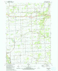
1991 Map of Goodells
USGS Topo · Published 1991About this map
Goodells serves as a central hub in this St. Clair County landscape, situated near the South Branch Pine River and the local Fairground. The map documents a predominantly rural township structure defined by the townships of Kenockee, Wales, and Columbus. This era is characterized by the convergence of agricultural drainage networks, such as Smiths Creek and Indian Creek, with the expanding regional infrastructure represented by the interstate corridor and the Grand Trunk Western railroad line.
Find a feature on this map
79 named features on this map. Tap any name to fly to it.
Don’t see what you’re looking for? This feature index may not catch every label — zoom into the map to look around manually.
Map Details
Editions of this 1991 Goodells Map
This is the sole edition of this map. No revisions or reprints were ever made.
Other maps of this area

1914 · Armada
USGS Topo · 1:62,500

1928 · Armada
USGS Topo · 1:62,500

1928 · Hicky
USGS Topo · 1:62,500

1936 · Rattle Run
USGS Topo · 1:31,680

1939 · Adair
USGS Topo · 1:24,000

1939 · Smiths Creek
USGS Topo · 1:24,000

1939 · Goodells
USGS Topo · 1:24,000

1942 · Rattle Run
USGS Topo · 1:24,000

1944 · Memphis
USGS Topo · 1:24,000

1945 · Richmond
USGS Topo · 1:24,000