
1945 Map of Richmond
USGS Topo · Published 1945About this map
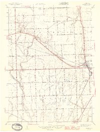
The Grand Trunk Western railroad cuts a diagonal line through this Macomb County landscape, anchoring the bustling trade center at Richmond and the neighboring settlement of Lenox. In the mid-1940s, this region was a dense network of family farms and small rural communities, as evidenced by the high concentration of country schools. From Highbank Sch in the west to Sullivan Sch in the southeast, these one-room schoolhouses served as local anchors for township life.
Find a feature on this map
57 named features on this map. Tap any name to fly to it.
Don’t see what you’re looking for? This feature index may not catch every label — zoom into the map to look around manually.
Map Details
Editions of this 1945 Richmond Map
2 editions found
Other maps of this area

1912 · Mt Clemens
USGS Topo · 1:62,500

1914 · Armada
USGS Topo · 1:62,500

1914 · Algonac
USGS Topo · 1:62,500

1928 · Armada
USGS Topo · 1:62,500

1928 · Hicky
USGS Topo · 1:62,500

1929 · Mt Clemens
USGS Topo · 1:62,500

1936 · New Haven
USGS Topo · 1:31,680

1936 · Waldenburg
USGS Topo · 1:31,680

1936 · New Baltimore
USGS Topo · 1:31,680

1939 · New Baltimore
USGS Topo · 1:24,000