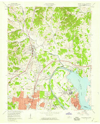
1957 Map of Goodlettsville
USGS Topo · Published 1959About this map
Goodlettsville and the industrial corridors of northern Davidson County are captured here at a moment of significant mid-century expansion. The Cumberland River anchors the geography, showing the newly established Old Hickory Lake behind the Old Hickory Dam. This hydraulic transformation reshaped the river's character near Hadley Bend and Rayon City, where the industrial footprint of Old Hickory stands in contrast to the residential growth spreading north from Madison.
Find a feature on this map
60 named features on this map. Tap any name to fly to it.
Don’t see what you’re looking for? This feature index may not catch every label — zoom into the map to look around manually.
Map Details
Editions of this 1957 Goodlettsville Map
This is the sole edition of this map. No revisions or reprints were ever made.
Other maps of this area

1903 · Nashville
USGS Topo · 1:125,000

1931 · Ridgetop
USGS Topo · 1:62,500

1932 · Hermitage
USGS Topo · 1:62,500

1932 · Nashville
USGS Topo · 1:62,500

1935 · Ridgetop
USGS Topo · 1:62,500

1942 · Gallatin
USGS Topo · 1:100,000

1942 · Lebanon
USGS Topo · 1:100,000

1952 · Goodlettsville
USGS Topo · 1:24,000

1952 · Hendersonville
USGS Topo · 1:24,000

1952 · Hermitage
USGS Topo · 1:24,000