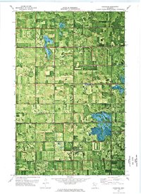
1972 Map of Goodridge
USGS Topo · Published 1976About this map
Goodridge serves as the primary hub of activity in this northwestern Minnesota landscape, where the 1972 topography reflects a region shaped by extensive water management and early transit corridors. The geometric grid of the Grand Plain and Moylan is defined by a dense network of man-made waterways, including Judicial Ditch No 13 and County Ditch No 20, which were critical for draining the low-lying prairie for agricultural use.
Find a feature on this map
17 named features on this map. Tap any name to fly to it.
Don’t see what you’re looking for? This feature index may not catch every label — zoom into the map to look around manually.
Map Details
Editions of this 1972 Goodridge Map
This is the sole edition of this map. No revisions or reprints were ever made.
Other maps of this area

1918 · Rollis
USGS Topo · 1:62,500

1919 · Liner
USGS Topo · 1:62,500

1943 · Rollis
USGS Topo · 1:62,500

1954 · Roseau
USGS Topo · 1:250,000

1957 · Roseau
USGS Topo · 1:250,000

1958 · Roseau
USGS Topo · 1:250,000

1962 · Gatzke SE
USGS Topo · 1:24,000
1962 · Gatzke SW
USGS Topo · 1:24,000

1972 · Erie
USGS Topo · 1:24,000
1972 · Goodridge SW
USGS Topo · 1:24,000