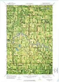
1972 Map of Goodridge SW
USGS Topo · Published 1976About this map
The Red Lake River meanders across this rural section of Pennington County, defining a landscape shaped by early agricultural drainage systems. Surveyed in the early 1970s, the terrain is organized into distinct townships including Silverton, Clover Leaf, Kratka, Wyandotte, and Mayfield. A network of managed waterways, such as County Ditch No 44 and County Ditch No 51, illustrates the regional commitment to reclaiming wetlands for productive prairie farmland. Local community life is anchored by the Telemarken Ch (Cem) and multiple Townhall locations. The introduction of industrial infrastructure is evident through a prominent Pipeline corridor cutting across the river valley, while a Gravel Pit reflects the local demand for road-building materials during this era of rural development.
Find a feature on this map
17 named features on this map. Tap any name to fly to it.
Don’t see what you’re looking for? This feature index may not catch every label — zoom into the map to look around manually.
Map Details
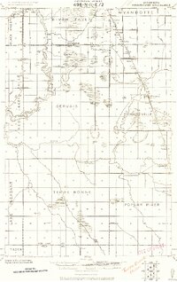
Editions of this 1972 Goodridge SW Map
This is the sole edition of this map. No revisions or reprints were ever made.
Other maps of this area
1918 · Terrebonne
USGS Topo · 1:62,500
1919 · Grit
USGS Topo · 1:62,500
1943 · Thief River Falls
USGS Topo · 1:62,500

1952 · Grand Forks
USGS Topo · 1:250,000

1952 · Thief River Falls
USGS Topo · 1:250,000

1954 · Bemidji
USGS Topo · 1:250,000

1954 · Roseau
USGS Topo · 1:250,000

1956 · Thief River Falls
USGS Topo · 1:250,000

1956 · Grand Forks
USGS Topo · 1:250,000

1957 · Roseau
USGS Topo · 1:250,000