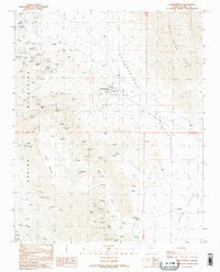
1989 Map of Goodsprings
USGS Topo · Published 1990About this map
Goodsprings stands as the primary hub of this high-desert mining landscape in the late 1980s, flanked by the steep ridges of the Spring Mountains and the Bird Spring Range. The settlement is surrounded by an incredible density of hard-rock mining history, with dozens of named operations including the Yellow Pine Mine, Prairie Flower Mine, and Monte Cristo Mine dotting the hillsides. A local Cem and a Radio Tower provide community landmarks amidst the myriad of Adits, Prospects, and Mine Shafts that define the local economy.
Find a feature on this map
56 named features on this map. Tap any name to fly to it.
Don’t see what you’re looking for? This feature index may not catch every label — zoom into the map to look around manually.
Map Details
Editions of this 1989 Goodsprings Map
2 editions found
Other maps of this area

1910 · Ivanpah
USGS Topo · 1:250,000

1912 · Ivanpah
USGS Topo · 1:250,000

1942 · Ivanpah
USGS Topo · 1:250,000

1947 · Kingman
USGS Topo · 1:250,000

1948 · Kingman
USGS Topo · 1:250,000

1954 · Kingman
USGS Topo · 1:250,000

1955 · Kingman
USGS Topo · 1:250,000

1955 · Roach Lake
USGS Topo · 1:62,500

1956 · Clark Mountain
USGS Topo · 1:62,500

1956 · Shenandoah Peak
USGS Topo · 1:62,500