
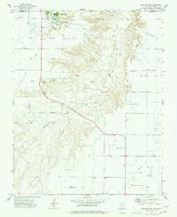
1973 Map of Goodwell SE
USGS Topo · Published 1975About this map
The Chicago Rock Island and Pacific railroad cuts a diagonal path through the high plains of the Oklahoma panhandle, anchoring the small settlement of Goodwell. Just outside the town limits, the Panhandle State College Farm reflects the region's agricultural research focus. The landscape is defined by a dense network of gas wells and the meandering path of the North Fork Frisco Creek, which carves subtle relief into the terrain as it flows toward the Frisco Cem. The prevalence of Caliche Pits and Gravel Pits across the landscape points to the localized extraction of road-building materials necessary for maintaining the grid of section lines in this expansive energy-producing district.
Find a feature on this map
13 named features on this map. Tap any name to fly to it.
Don’t see what you’re looking for? This feature index may not catch every label — zoom into the map to look around manually.
Map Details
Editions of this 1973 Goodwell SE Map
This is the sole edition of this map. No revisions or reprints were ever made.
Other maps of this area

1954 · Perryton
USGS Topo · 1:250,000

1958 · Perryton
USGS Topo · 1:250,000

1968 · Guymon
USGS Topo · 1:24,000

1968 · Guymon SW
USGS Topo · 1:24,000

1973 · Goodwell NW
USGS Topo · 1:24,000

1973 · Goodwell
USGS Topo · 1:24,000

1973 · Goodwell NE
USGS Topo · 1:24,000

1974 · Sunray 1 NW
USGS Topo · 1:24,000

1974 · Sunray 1 NE
USGS Topo · 1:24,000
1974 · Phillips Camp
USGS Topo · 1:24,000