
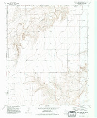
1974 Map of Sunray 1 NE
USGS Topo · Published 1977About this map
Frisco Creek and Coldwater Creek carve distinct drainage patterns across this High Plains landscape along the Texas-Oklahoma border in the mid-1970s. The map illustrates a rural economy transitioning between traditional agriculture and modern energy extraction, evidenced by the high concentration of gas wells and extensive pipelines traversing the terrain. Local history centers on small community landmarks like the Olso Church and its adjacent cemetery, which serve as anchors for the dispersed homesteads in Hansford Co and Sherman Co. Named locales such as Graham and Doyle provide specific points of interest for genealogists tracing family ties to this corner of the Panhandle. The presence of a Gravel Pit and numerous survey marks reflects the ongoing infrastructure development of the era.
Find a feature on this map
12 named features on this map. Tap any name to fly to it.
Don’t see what you’re looking for? This feature index may not catch every label — zoom into the map to look around manually.
Map Details
Editions of this 1974 Sunray 1 NE Map
2 editions found
Other maps of this area

1954 · Perryton
USGS Topo · 1:250,000

1958 · Perryton
USGS Topo · 1:250,000

1968 · Guymon SW
USGS Topo · 1:24,000

1973 · Goodwell SE
USGS Topo · 1:24,000

1973 · Goodwell
USGS Topo · 1:24,000

1973 · Gruver
USGS Topo · 1:24,000

1974 · Sunray 1 NW
USGS Topo · 1:24,000

1974 · Sunray 1 SW
USGS Topo · 1:24,000

1974 · Sunray 1 SE
USGS Topo · 1:24,000
1974 · Phillips Camp
USGS Topo · 1:24,000