
1974 Map of Sunray 1 SW
USGS Topo · Published 1977About this map
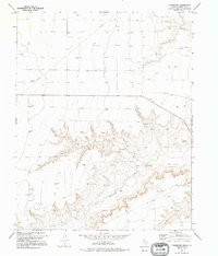
Coldwater Creek carves a deep, dendritic drainage pattern across this section of the Texas Panhandle, contrasting sharply with the level high plains of Sherman County. In the mid-1970s, this landscape was defined by its intensive energy extraction, with a dense grid of Gas Wells and Oil Wells scattered across the northern and southern plateaus. A complex network of Pipelines cuts diagonally across the terrain, illustrating the infrastructure required to transport fuel from these remote fields. While the creek bottom provides a natural break in the topography, the primary human activity is clearly visible in the systematic placement of drill sites and the unimproved roads that link them, showing the industrial character of the region during this era of petroleum development.
Find a feature on this map
4 named features on this map. Tap any name to fly to it.
Don’t see what you’re looking for? This feature index may not catch every label — zoom into the map to look around manually.
Map Details
Editions of this 1974 Sunray 1 SW Map
2 editions found
Other maps of this area

1954 · Perryton
USGS Topo · 1:250,000

1958 · Perryton
USGS Topo · 1:250,000

1974 · Sunray 1 NW
USGS Topo · 1:24,000

1974 · Texhoma South
USGS Topo · 1:24,000

1974 · Stevens SE
USGS Topo · 1:24,000

1974 · Sunray 1 SE
USGS Topo · 1:24,000

1974 · Capps Switch NW
USGS Topo · 1:24,000
1974 · Pleasure Pond
USGS Topo · 1:24,000

1974 · Hannas Draw West
USGS Topo · 1:24,000

1974 · Sunray 1 NE
USGS Topo · 1:24,000