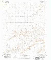
1974 Map of Coldwater Creek
USGS Topo · Published 1995About this map
Coldwater Creek carves a deep, dendritic drainage system through the high plains of the Texas Panhandle, creating a sharp contrast between the flat upland plateau and the eroded breaks of the canyon floor. During the mid-1970s, this landscape was defined by an extensive energy infrastructure, with dozens of active Gas Well and Oil Well sites scattered across the sections. The industrial footprint is further emphasized by a network of Pipelines and smaller Pipe connections that crisscross the terrain to transport resources from the remote fields. This survey captures the region just as modern aerial mapping techniques were refining the documentation of these isolated energy corridors in Sherman County.
Find a feature on this map
7 named features on this map. Tap any name to fly to it.
Don’t see what you’re looking for? This feature index may not catch every label — zoom into the map to look around manually.
Map Details
Editions of this 1974 Coldwater Creek Map
2 editions found
Other maps of this area

1954 · Perryton
USGS Topo · 1:250,000

1958 · Perryton
USGS Topo · 1:250,000

1974 · Sunray 1 NW
USGS Topo · 1:24,000

1974 · Texhoma South
USGS Topo · 1:24,000

1974 · Stevens SE
USGS Topo · 1:24,000

1974 · Sunray 1 SW
USGS Topo · 1:24,000

1974 · Sunray 1 SE
USGS Topo · 1:24,000

1974 · Capps Switch NW
USGS Topo · 1:24,000
1974 · Pleasure Pond
USGS Topo · 1:24,000

1974 · Hannas Draw West
USGS Topo · 1:24,000