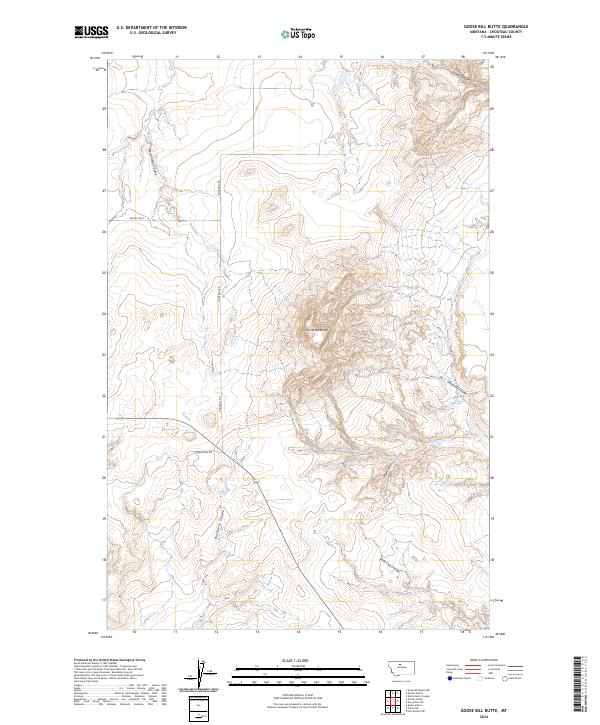
2024 Map of Goose Bill Butte
USGS Topo · Published 2024About this map
Goose Bill Butte dominates this central Montana landscape, where the high plains are deeply etched by a complex network of ephemeral drainages. The topography is defined by the sharp contrast between the prominent central butte and the radiating coulees that carve through the surrounding agricultural lands. Notable watercourses including Sheep Coulee, Dead Indian Coulee, and Goose Bill Coulee indicate a region shaped by sudden runoff and erosion. Human presence is marked primarily by rural access roads like Goosebill Rd and Dahlstrom Dr, which trace the grid of the Public Land Survey System across the townships. This 2024 survey documents the enduring physical character of the Highwood area, emphasizing the landforms and seasonal creeks that dictate the geography of Chouteau County ranching and farming operations.
Find a feature on this map
15 named features on this map. Tap any name to fly to it.
Don’t see what you’re looking for? This feature index may not catch every label — zoom into the map to look around manually.
Map Details
Editions of this 2024 Goose Bill Butte Map
This is the sole edition of this map. No revisions or reprints were ever made.
Other maps of this area

1890 · Fort Benton
USGS Topo · 1:250,000

1892 · Fort Benton
USGS Topo · 1:250,000

1897 · Fort Benton
USGS Topo · 1:250,000

1954 · Great Falls
USGS Topo · 1:250,000

1954 · Shelby
USGS Topo · 1:250,000

1957 · Great Falls
USGS Topo · 1:250,000

1958 · Shelby
USGS Topo · 1:250,000
1964 · Fort Benton NW
USGS Topo · 1:24,000
1964 · Day School SW
USGS Topo · 1:24,000

1969 · Dutch Henry Coulee
USGS Topo · 1:24,000