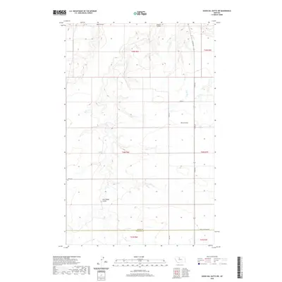
2020 Map of Goose Bill Butte NW
USGS Topo · Published 2020About this map
The Liberty and Chouteau County line bisects this northern Montana landscape, where the high plains are carved by a system of deep drainages. This high-plateau terrain is defined by the winding paths of Basin Coulee, Dugout Coulee, and Horse Coulee, which create significant relief in an otherwise expansive agricultural and grazing region. Evidence of early settlement and family history is found at the Wolfe Cem, located in the western portion of the map. The human footprint is marked by a precise grid of county roads, including Co Rd 223 and Egly Rd, which follow the section lines of the Public Land Survey System. The transition between Township 29 North and Township 28 North highlights the late 20th and early 21st-century management of these rural lands, where the natural watercourses like East Dugout Coulee continue to dictate the movement of people and livestock.
Find a feature on this map
16 named features on this map. Tap any name to fly to it.
Don’t see what you’re looking for? This feature index may not catch every label — zoom into the map to look around manually.
Map Details
Editions of this 2020 Goose Bill Butte NW Map
This is the sole edition of this map. No revisions or reprints were ever made.
Other maps of this area

1954 · Shelby
USGS Topo · 1:250,000

1958 · Shelby
USGS Topo · 1:250,000

1970 · Circle Bridge
USGS Topo · 1:24,000

1970 · Penzer School
USGS Topo · 1:24,000
1970 · Dorner School
USGS Topo · 1:24,000

1970 · Uphill Creek
USGS Topo · 1:24,000

1970 · Poverty Coulee SE
USGS Topo · 1:24,000

1970 · Goose Bill Butte NW
USGS Topo · 1:24,000
1970 · Russell Chapel
USGS Topo · 1:24,000
1970 · Goose Bill Butte
USGS Topo · 1:24,000