
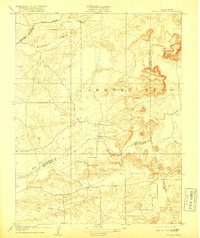
1909 Map of Goose Creek
USGS Topo · Published 1909About this map
The rolling lands east of Galt and south of the Cosumnes River are defined by the convergence of three counties in this early 20th-century topographic record. The Southern Pacific R. R. traverses the northwestern corner along the (Amador Branch) line, connecting the rural uplands to the broader California rail network. Settlement patterns here are sparse and centered around seasonal watercourses and essential civic infrastructure like the Hutson School, which served the local ranching community near the Dry Creek drainage. The landscape is dominated by the broad, etched terrain of the Arroyo Seco, where the boundaries of Sacramento, Amador, and San Joaquin counties meet. This survey captures the transition from the flat Central Valley into the lower foothills, highlighting the reliance on local water bodies such as Hadselville Creek and Goose Creek before the widespread industrialization of the region's agriculture.
Find a feature on this map
11 named features on this map. Tap any name to fly to it.
Don’t see what you’re looking for? This feature index may not catch every label — zoom into the map to look around manually.
Map Details
Editions of this 1909 Goose Creek Map
2 editions found
Other maps of this area

1889 · Jackson
USGS Topo · 1:125,000

1892 · Jackson
USGS Topo · 1:125,000

1894 · Lodi
USGS Topo · 1:125,000

1897 · Jackson
USGS Topo · 1:125,000

1902 · Jackson
USGS Topo · 1:125,000

1908 · Lockeford
USGS Topo · 1:31,680

1909 · Carbondale
USGS Topo · 1:31,680

1909 · Clay
USGS Topo · 1:31,680

1909 · Cosumnes
USGS Topo · 1:31,680

1909 · Clements
USGS Topo · 1:31,680