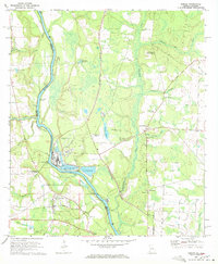
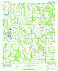
1970 Map of Gordon
USGS Topo · Published 1972About this map
The Chattahoochee River defines the border between Houston County, Alabama and Early County, Georgia in this 1970 landscape. The town of Gordon serves as a local hub near the Seaboard Coast Line railroad, which crosses the river at Alaga. This era shows a mix of traditional agricultural settlements and emerging 20th-century industry, particularly near Smith Bend where the Great Northern Airport and several Industrial Waste Ponds are situated. Rural life is anchored by numerous community landmarks such as St Stephens Ch, Liberty Ch, and Carver Sch. The map also captures several historic river access points, including Upper Gordon Landing and Hayesville Landing, reflecting the river's enduring role in local transport and commerce. Tributaries like Sawhatchee Creek and Wilson Creek snake through the terrain, feeding into the main channel near the Cedar Springs community.
Find a feature on this map
49 named features on this map. Tap any name to fly to it.
Don’t see what you’re looking for? This feature index may not catch every label — zoom into the map to look around manually.
Map Details
Editions of this 1970 Gordon Map
3 editions found
Other maps of this area

1953 · Dothan
USGS Topo · 1:250,000

1954 · Dothan
USGS Topo · 1:250,000

1955 · Dothan
USGS Topo · 1:250,000

1970 · Gordon
USGS Topo · 1:24,000
1970 · Saffold
USGS Topo · 1:24,000

1970 · Sigma
USGS Topo · 1:24,000

1970 · Columbia
USGS Topo · 1:24,000
1970 · Grangeburg
USGS Topo · 1:24,000
1970 · Ashford
USGS Topo · 1:24,000

1973 · Blakely South
USGS Topo · 1:24,000