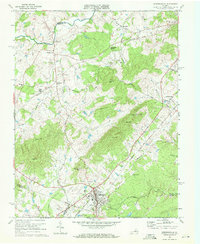
1970 Map of Gordonsville
USGS Topo · Published 1972About this map
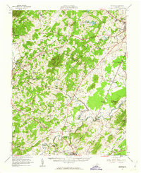
Gordonsville sits at a strategic junction of the Chesapeake and Ohio and Southern railroads, anchoring this landscape where the Piedmont meets the Southwest Mountains. The map illustrates a rural Virginia economy in 1970, with the Gordonsville Airport and a local Drive-in Theater serving the community alongside traditional landmarks like the James Madison Sch and Maplewood Cem. To the north, Montpelier Station and Liberty Mills mark established points along the Rapidan River, which forms the boundary with Madison County. Significant topography including Chicken Mtn, Merry Mtn, and Smith Hill shapes the drainage of Blue Run and Bacon Run. This survey captures the region just before modern expansion, preserving the locations of rural congregations like Blue Run Ch and Oak Chapel and small crossroads like Jacksontown.
Find a feature on this map
48 named features on this map. Tap any name to fly to it.
Don’t see what you’re looking for? This feature index may not catch every label — zoom into the map to look around manually.
Map Details
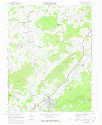
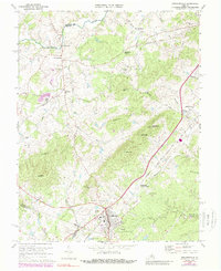
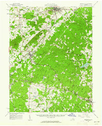
Editions of this 1970 Gordonsville Map
3 editions found
Other maps of this area

1892 · Gordonsville
USGS Topo · 1:125,000

1930 · Madison
USGS Topo · 1:48,000

1933 · Madison
USGS Topo · 1:62,500

1935 · Charlottesville
USGS Topo · 1:62,500

1939 · Charlottesville
USGS Topo · 1:62,500

1949 · Charlottesville
USGS Topo · 1:250,000

1949 · Charlottesville
USGS Topo · 1:62,500

1956 · Charlottesville
USGS Topo · 1:250,000
1961 · Gordonsville
USGS Topo · 1:62,500
1961 · Rapidan
USGS Topo · 1:62,500