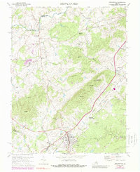
1970 Map of Gordonsville
USGS Topo · Published 1989About this map
Montpelier, the historic estate of James Madison, anchors the northern landscape of this map, featuring the James Madison Cem and the nearby Montpelier Station. The survey area centers on the strategic junction of the Southern and Chesapeake and Ohio railroads at Gordonsville, highlighting the town's importance as a regional transportation hub. The terrain is defined by a series of prominent peaks including Scott Mtn, Merry Mtn, and Chicken Mtn, which overlook the winding course of the Rapidan River and Blue Run. Local industry and commerce are evident through features like the Claypit near Somerset and the Gordonsville Municipal Airport. Small settlements such as Liberty Mills, Old Somerset, and Jacksontown are interspersed among numerous country churches, including Oak Chapel and Zion Ch, reflecting the established rural community structure of Piedmont Virginia.
Find a feature on this map
51 named features on this map. Tap any name to fly to it.
Don’t see what you’re looking for? This feature index may not catch every label — zoom into the map to look around manually.
Map Details
Editions of this 1970 Gordonsville Map
3 editions found

Other maps of this area

1892 · Gordonsville
USGS Topo · 1:125,000

1930 · Madison
USGS Topo · 1:48,000

1933 · Madison
USGS Topo · 1:62,500

1935 · Charlottesville
USGS Topo · 1:62,500

1939 · Charlottesville
USGS Topo · 1:62,500

1949 · Charlottesville
USGS Topo · 1:250,000

1949 · Charlottesville
USGS Topo · 1:62,500

1956 · Charlottesville
USGS Topo · 1:250,000

1961 · Gordonsville
USGS Topo · 1:62,500

1961 · Rapidan
USGS Topo · 1:62,500