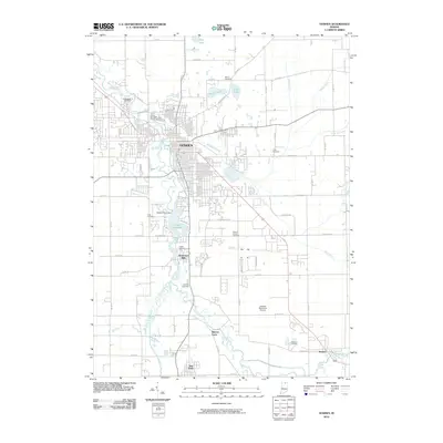
2010 Map of Goshen
USGS Topo · Published 2010About this map
The Elkhart River serves as the primary geographic corridor through this section of Elkhart County, anchoring the city of Goshen and several smaller outlying settlements. By the early 21st century, the landscape reflects a complex network of water management features, including the Goshen Pond Dam and the associated Goshen Dam Pond, alongside a grid of agricultural drainage such as Hoover Ditch and Boyer Ditch.
Find a feature on this map
64 named features on this map. Tap any name to fly to it.
Don’t see what you’re looking for? This feature index may not catch every label — zoom into the map to look around manually.
Map Details
Editions of this 2010 Goshen Map
This is the sole edition of this map. No revisions or reprints were ever made.
Other maps of this area

1951 · Milford
USGS Topo · 1:24,000

1951 · Wawasee
USGS Topo · 1:24,000

1953 · Fort Wayne
USGS Topo · 1:250,000

1956 · Fort Wayne
USGS Topo · 1:250,000

1958 · Nappanee East
USGS Topo · 1:24,000

1959 · Millersburg
USGS Topo · 1:24,000

1959 · Goshen
USGS Topo · 1:24,000

1960 · Foraker
USGS Topo · 1:24,000
1961 · Lake Wawasee
USGS Topo · 1:24,000
1961 · Bristol
USGS Topo · 1:24,000