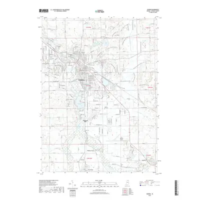
2019 Map of Goshen
USGS Topo · Published 2019About this map
Goshen serves as the central hub of this Indiana landscape, where the Elkhart River and Rock Run Creek define the local topography. This 2019 survey shows a modern transportation and recreation network, including the Pumpkinvine Nature Trail and the seasonal Miami Snowmobile Trail that crisscrosses the eastern rural areas. The map is particularly useful for genealogical research, documenting several burial grounds like Violett Cemetery near Waterford Mills and Sparklin Cemetery further south. The southern portion of the quadrangle includes the distinct settlements of Bainter Town, New Paris, and Benton, each situated along the river's path. Infrastructure like the Goshen Municipal Airport and the Goshen Dam Pond highlight the area's development, while numerous drainage features such as Hoover Ditch and Boyer Ditch reveal the agricultural management of the surrounding Elkhart County terrain.
Find a feature on this map
82 named features on this map. Tap any name to fly to it.
Don’t see what you’re looking for? This feature index may not catch every label — zoom into the map to look around manually.
Map Details
Editions of this 2019 Goshen Map
This is the sole edition of this map. No revisions or reprints were ever made.
Other maps of this area

1951 · Milford
USGS Topo · 1:24,000

1951 · Wawasee
USGS Topo · 1:24,000

1953 · Fort Wayne
USGS Topo · 1:250,000

1956 · Fort Wayne
USGS Topo · 1:250,000

1958 · Nappanee East
USGS Topo · 1:24,000

1959 · Millersburg
USGS Topo · 1:24,000

1959 · Goshen
USGS Topo · 1:24,000

1960 · Foraker
USGS Topo · 1:24,000
1961 · Lake Wawasee
USGS Topo · 1:24,000
1961 · Bristol
USGS Topo · 1:24,000