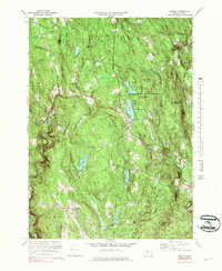
1972 Map of Goshen
USGS Topo · Published 1983About this map
The Daughters of the American Revolution State Forest dominates this landscape, encompassing the central highlands where Highland Lakes and several youth camps, including Camp Holy Cross and Camp Howe, are situated. The 1970s terrain is defined by a series of prominent peaks and wetlands, with Mollison Hill and Merritts Hill rising above the surrounding brooks. Settlement is concentrated in the small villages of Goshen and Lithia, connected by a network of rural routes such as Plainfield Road and Stages Road.
Find a feature on this map
67 named features on this map. Tap any name to fly to it.
Don’t see what you’re looking for? This feature index may not catch every label — zoom into the map to look around manually.
Map Details
Editions of this 1972 Goshen Map
4 editions found
Other maps of this area

1885 · Northampton
USGS Topo · 1:62,500

1886 · Hawley
USGS Topo · 1:62,500

1886 · Chesterfield
USGS Topo · 1:62,500

1886 · Northampton
USGS Topo · 1:62,500

1888 · Chesterfield
USGS Topo · 1:62,500

1890 · Hawley
USGS Topo · 1:62,500

1890 · Greenfield
USGS Topo · 1:62,500

1891 · Northampton
USGS Topo · 1:62,500

1893 · Northampton
USGS Topo · 1:62,500

1893 · Chesterfield
USGS Topo · 1:62,500