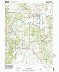
1998 Map of Gosport
USGS Topo · Published 2002About this map
The White River carves a deep, winding path through the borderlands of Owen and Monroe counties, anchoring the commercial and industrial layout of this landscape. In Gosport, the town's position at the river's bend is marked by its historic grid and the Gosport Cem overlooking the water. To the south, the limestone industry is clearly visible through a dense concentration of quarries and quarries around Stinesville and Romona, highlighting the area's geological importance to Indiana's stone production.
Find a feature on this map
64 named features on this map. Tap any name to fly to it.
Don’t see what you’re looking for? This feature index may not catch every label — zoom into the map to look around manually.
Map Details
Editions of this 1998 Gosport Map
This is the sole edition of this map. No revisions or reprints were ever made.
Other maps of this area

1908 · Bloomington
USGS Topo · 1:48,000

1908 · Bloomfield
USGS Topo · 1:62,500

1910 · Bloomington
USGS Topo · 1:62,500

1947 · Gosport
USGS Topo · 1:24,000

1949 · Quincy
USGS Topo · 1:24,000

1950 · Gosport
USGS Topo · 1:24,000

1953 · Indianapolis
USGS Topo · 1:250,000

1956 · Indianapolis
USGS Topo · 1:250,000

1956 · Cataract
USGS Topo · 1:24,000

1956 · Freedom
USGS Topo · 1:24,000