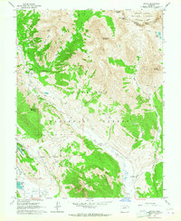
1961 Map of Gothic
USGS Topo · Published 1964About this map
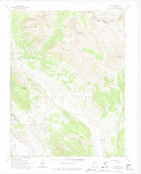
Gothic stands at the heart of this high-altitude landscape, a settlement positioned at the confluence of several mountain basins as they appeared in the early 1960s. The terrain transitions from the headwaters of the Slate River and East River toward the dramatic peaks of the Elk Mountains, marking the boundary between the Gunnison National Forest and White River National Forest. The presence of a Cem near the river and the Brush Creek Cow Camp further south suggests the intersection of early settlement life with seasonal ranching operations. Outdoor recreation infrastructure is already taking shape near Crested Butte, evidenced by a Ski Tow and Gondola Lift. Notable landmarks like Judd Falls and the high Triangle Pass define the passage through these peaks, while labels such as Prospect hint at the area's earlier mining interests.
Find a feature on this map
32 named features on this map. Tap any name to fly to it.
Don’t see what you’re looking for? This feature index may not catch every label — zoom into the map to look around manually.
Map Details
Editions of this 1961 Gothic Map
7 editions found
Other maps of this area

1888 · Crested Butte
USGS Topo · 1:62,500

1888 · Anthracite
USGS Topo · 1:62,500

1889 · Crested Butte
USGS Topo · 1:62,500

1889 · Anthracite
USGS Topo · 1:62,500

1893 · Anthracite
USGS Topo · 1:62,500

1893 · Crested Butte
USGS Topo · 1:62,500

1893 · Aspen
USGS Topo · 1:62,500

1894 · Anthracite
USGS Topo · 1:62,500

1895 · Aspen
USGS Topo · 1:62,500

1909 · Mount Jackson
USGS Topo · 1:125,000