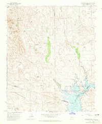
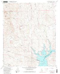
1964 Map of Governors Peak
USGS Topo · Published 1965About this map
Castle Hot Springs sits at the heart of this desert landscape, surrounded by the dramatic terrain of the Hieroglyphic Mountains. The map reveals a land of hidden water sources and ancient history, evidenced by the noted Petroglyphs near Tule Creek and the numerous springs like Alkali Spring and Mud Spring that dot the arid basins. To the southeast, the rising waters of Lake Pleasant and the Agua Fria River define the boundary between Yavapai and Maricopa counties.
Find a feature on this map
38 named features on this map. Tap any name to fly to it.
Don’t see what you’re looking for? This feature index may not catch every label — zoom into the map to look around manually.
Map Details
Editions of this 1964 Governors Peak Map
5 editions found
Other maps of this area

1887 · Prescott
USGS Topo · 1:250,000

1892 · Prescott
USGS Topo · 1:250,000

1903 · Bradshaw Mountains
USGS Topo · 1:125,000

1947 · Crown King
USGS Topo · 1:62,500

1947 · Bumblebee
USGS Topo · 1:62,500

1948 · Bumblebee
USGS Topo · 1:63,360

1948 · Crown King
USGS Topo · 1:63,360

1950 · Crown King
USGS Topo · 1:62,500

1950 · Bumblebee
USGS Topo · 1:62,500

1950 · Prescott
USGS Topo · 1:250,000