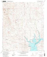
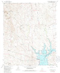
1964 Map of Governors Peak
USGS Topo · Published 1986About this map
Castle Hot Springs stands as a focal point in this 1964 survey, tucked into the foothills north of the Hieroglyphic Mountains. The landscape transitions from the high peaks of Governors Peak and Salvation Peak down toward the spreading waters of Lake Pleasant and the Agua Fria River. This period of mapping documents the early footprint of Lake Pleasant Regional Park, showing the Spillway and the controlled inundation areas along the river's path. Cultural history is evident in the marking of Petroglyphs near Tule Spring and the Gila and Salt River Meridian, alongside a network of cattle-era infrastructure like Bog Ranch, various pack trails, and a remote Landing Strip situated along Castle Creek.
Find a feature on this map
43 named features on this map. Tap any name to fly to it.
Don’t see what you’re looking for? This feature index may not catch every label — zoom into the map to look around manually.
Map Details
Editions of this 1964 Governors Peak Map
5 editions found
Other maps of this area

1887 · Prescott
USGS Topo · 1:250,000

1892 · Prescott
USGS Topo · 1:250,000

1903 · Bradshaw Mountains
USGS Topo · 1:125,000

1947 · Crown King
USGS Topo · 1:62,500

1947 · Bumblebee
USGS Topo · 1:62,500

1948 · Bumblebee
USGS Topo · 1:63,360

1948 · Crown King
USGS Topo · 1:63,360

1950 · Crown King
USGS Topo · 1:62,500

1950 · Bumblebee
USGS Topo · 1:62,500

1950 · Prescott
USGS Topo · 1:250,000