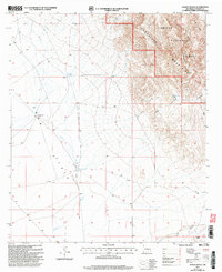
2001 Map of Gowdy Ranch
USGS Topo · Published 2003About this map
Crow Flats and the rising slopes of the Guadalupe Mountains dominate this high-desert landscape in Otero County. The map details a transition from the broad, open expanse of the flats to the complex canyon systems of the Lincoln National Forest, marked by The Rim. Water security for livestock and remote living is a central theme of the layout, shown through scattered infrastructure like Browning Well, Woods Tank, and several other numbered wells and tanks. The ephemeral drainage of Piñon Wash snakes through the center of the sheet, providing a vital geographic corridor between the Gowdy Ranch and the southern Rauch Ranch. This 2001 revision illustrates the enduring layout of the ranching economy and the rugged physical barriers found in Little Dog Canyon and Box Canyon.
Find a feature on this map
21 named features on this map. Tap any name to fly to it.
Don’t see what you’re looking for? This feature index may not catch every label — zoom into the map to look around manually.
Map Details
Editions of this 2001 Gowdy Ranch Map
This is the sole edition of this map. No revisions or reprints were ever made.
Other maps of this area

1935 · El Paso Gap
USGS Topo · 1:62,500

1936 · El Paso Gap
USGS Topo · 1:48,000

1940 · El Paso Gap
USGS Topo · 1:62,500

1943 · Texas Hill
USGS Topo · 1:62,500

1945 · Texas Hill
USGS Topo · 1:62,500

1954 · Carlsbad
USGS Topo · 1:250,000

1958 · Carlsbad
USGS Topo · 1:250,000

1963 · Hackberry Hill
USGS Topo · 1:24,000

1963 · Tanner Ranch
USGS Topo · 1:24,000

1963 · Gowdy Ranch
USGS Topo · 1:24,000