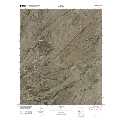
2010 Map of Gozar
USGS Topo · Published 2010About this map
Gozar occupies a wide expanse of the Trans-Pecos landscape where seasonal drainage systems define the geography. These ephemeral waterways, including San Martine Draw, Moody Draw, and Hanwell Draw, etch a network across the arid terrain of Reeves County. The map shows the infrastructure of cattle ranching and early settlement, with local landmarks like the Old House Place and Three Inch Windmill serving as isolated points of interest in an otherwise sparse environment. Water management is critical in this region, evidenced by the presence of Ramsey Tank and various other draws like Billingslea Draw and Ninemile Draw. The primary corridor of movement through this territory is the diagonal route of Interstate 10, which connects the small settlement areas with the broader West Texas region. Local roads such as Johnson Rd and Co Rd 335 provide access to more remote ranchland and the southern drainage of Sotol Draw.
Find a feature on this map
13 named features on this map. Tap any name to fly to it.
Don’t see what you’re looking for? This feature index may not catch every label — zoom into the map to look around manually.
Map Details
Editions of this 2010 Gozar Map
This is the sole edition of this map. No revisions or reprints were ever made.
Other maps of this area

1921 · Toyah
USGS Topo · 1:125,000

1928 · Kent
USGS Topo · 1:125,000

1954 · Van Horn
USGS Topo · 1:250,000

1954 · Pecos
USGS Topo · 1:250,000

1957 · Pecos
USGS Topo · 1:250,000

1958 · Van Horn
USGS Topo · 1:250,000

1970 · Florenzo Hill
USGS Topo · 1:24,000

1970 · Toyah
USGS Topo · 1:24,000
1970 · San Martine
USGS Topo · 1:24,000
1970 · Gozar
USGS Topo · 1:24,000