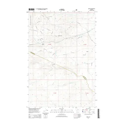
2014 Map of Grace
USGS Topo · Published 2014About this map
The settlement of Grace and the eastern slopes of the Boulder Mountains define this section of the Deerlodge National Forest along the border of Jefferson and Silver Bow counties. The high-altitude landscape is crisscrossed by historic routes and resource-focused names, including Old Telegraph Tr, Toll Mountain Rd, and Whiskey Gulch. These labels point toward the area's development through early communication lines and the mining-era economy. The terrain is deeply carved by drainage systems like Little Pipestone Cr, Rader Creek, and Fish Cr, which draw water from the high ridges down into the gulches. At Cedric and near Cedar Gulch, the map reveals a network of forest roads and trails, such as Ranger Ridge Rd and Lost Moose Bend Rd, that provide access to remote springs like Mud Springs and Poison Spring in this high-country environment.
Find a feature on this map
55 named features on this map. Tap any name to fly to it.
Don’t see what you’re looking for? This feature index may not catch every label — zoom into the map to look around manually.
Map Details
Editions of this 2014 Grace Map
This is the sole edition of this map. No revisions or reprints were ever made.
Other maps of this area

1893 · Dillon
USGS Topo · 1:250,000

1955 · Dillon
USGS Topo · 1:250,000

1957 · Dillon
USGS Topo · 1:250,000

1958 · Dillon
USGS Topo · 1:250,000

1960 · Twin Bridges
USGS Topo · 1:62,500

1960 · Waterloo
USGS Topo · 1:62,500

1962 · Dillon
USGS Topo · 1:250,000
1963 · Dry Mountain
USGS Topo · 1:24,000

1963 · Pipestone Pass
USGS Topo · 1:24,000

1963 · Vendome
USGS Topo · 1:24,000