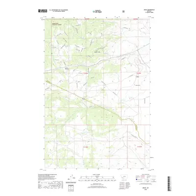
2020 Map of Grace
USGS Topo · Published 2020About this map
Deerlodge National Forest covers the northern reaches of this Montana landscape, where the Boulder Mountains rise above a network of drainages and timber roads. The topography is defined by the high elevations of Ranger Ridge and Sidetrack Hill, with early 21st-century settlements such as Grace and Cedric situated near the county line shared by Jefferson and Silver Bow Counties. The area is rich in water resources, including the headwaters of Fish Cr, Little Pipestone Cr, and Rader Cr, along with numerous named springs. A dense grid of mountain access roads like Toll Mtn Rd and Friend Spring Rd reflects the modern management of this timber and recreation land, while features like Lost Moose Bend and Cedar Gulch indicate the local character of the terrain.
Find a feature on this map
59 named features on this map. Tap any name to fly to it.
Don’t see what you’re looking for? This feature index may not catch every label — zoom into the map to look around manually.
Map Details
Editions of this 2020 Grace Map
This is the sole edition of this map. No revisions or reprints were ever made.
Other maps of this area

1893 · Dillon
USGS Topo · 1:250,000

1955 · Dillon
USGS Topo · 1:250,000

1957 · Dillon
USGS Topo · 1:250,000

1958 · Dillon
USGS Topo · 1:250,000

1960 · Twin Bridges
USGS Topo · 1:62,500

1960 · Waterloo
USGS Topo · 1:62,500

1962 · Dillon
USGS Topo · 1:250,000
1963 · Dry Mountain
USGS Topo · 1:24,000

1963 · Pipestone Pass
USGS Topo · 1:24,000

1963 · Vendome
USGS Topo · 1:24,000