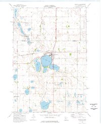
1974 Map of Graceville
USGS Topo · Published 1976About this map
The railroad junction at Graceville serves as the focal point of this western Minnesota prairie landscape, where the Burlington Northern and Chicago Milwaukee St Paul and Pacific lines intersect. The town is surrounded by a complex network of glacial lakes and sloughs, including East Toqua Lake and West Toqua Lake, which are preserved in part by Toqua Lakes Park. Further south, the Big Stone Colony appears as a distinct settlement near Lake Leo, illustrating the communal agricultural patterns typical of the region.
Find a feature on this map
33 named features on this map. Tap any name to fly to it.
Don’t see what you’re looking for? This feature index may not catch every label — zoom into the map to look around manually.
Map Details
Editions of this 1974 Graceville Map
This is the sole edition of this map. No revisions or reprints were ever made.
Other maps of this area

1916 · Beardsley
USGS Topo · 1:62,500

1918 · Beardsley
USGS Topo · 1:62,500

1950 · Graceville
USGS Topo · 1:62,500

1953 · Ortonville
USGS Topo · 1:62,500

1953 · Milbank
USGS Topo · 1:250,000

1954 · Big Stone Lake
USGS Topo · 1:62,500

1958 · Milbank
USGS Topo · 1:250,000

1971 · Big Stone Lake East
USGS Topo · 1:24,000

1971 · Dismal Swamp
USGS Topo · 1:24,000
1971 · Clinton
USGS Topo · 1:24,000
Featured Places
- Graceville, MN
- Big Stone Colony, MN
- Big Stone Hutterite Colony, MN
- Big Stone County, MN
- Traverse County, MN