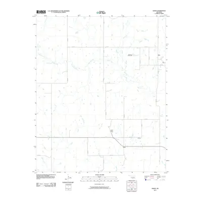
2010 Map of Grady
USGS Topo · Published 2010About this map
Mud Creek and its many tributaries, including West Mud Creek and Baker Creek, dominate this rural Oklahoma landscape. The settlement of Grady sits at a crossroads in the southern portion of the map, while Atlee is located to the northeast. This 2010 survey shows a region defined by agricultural land use and a grid-like road network, such as n2980 RD and e2010 RD. Genealogists will find the Grady Cemetery and Atlee Cemetery useful for documenting local family history. The presence of the Dennis Ranch Airport and the Oknoname 067006 Dam highlights the intersection of private aviation and water management in this part of Jefferson County.
Find a feature on this map
25 named features on this map. Tap any name to fly to it.
Don’t see what you’re looking for? This feature index may not catch every label — zoom into the map to look around manually.
Map Details
Editions of this 2010 Grady Map
This is the sole edition of this map. No revisions or reprints were ever made.
Other maps of this area

1901 · Addington
USGS Topo · 1:125,000

1905 · Montague
USGS Topo · 1:125,000

1954 · Sherman
USGS Topo · 1:250,000

1957 · Ardmore
USGS Topo · 1:250,000

1958 · Sherman
USGS Topo · 1:250,000

1962 · Ryan
USGS Topo · 1:62,500

1963 · Ardmore
USGS Topo · 1:250,000
1968 · Spanish Fort
USGS Topo · 1:24,000

1968 · Fleetwood
USGS Topo · 1:24,000
1968 · Prairie Valley School
USGS Topo · 1:24,000