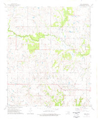
1974 Map of Grady
USGS Topo · Published 1977About this map
The Oscar Oil Field defines the southern landscape of this Jefferson County territory, where extractive industry meets the winding drainage of West Mud Creek. During the mid-1970s, the rural community of Grady sat as a central point of activity, connected by a prominent east-west Pipeline and a network of unimproved roads serving various Oil Wells. To the northeast, the settlement of Atlee and its associated Atlee Cem provide important genealogical markers for researchers of this Oklahoma-Texas border region. The terrain is characterized by the confluence of several water bodies, including Post Oak Creek and Baker Creek, which carve through the townships of Grayson, Wright, and Brown. This survey provides a clear look at the intersection of livestock ranching and petroleum production before further modernization altered the local footprint.
Find a feature on this map
17 named features on this map. Tap any name to fly to it.
Don’t see what you’re looking for? This feature index may not catch every label — zoom into the map to look around manually.
Map Details
Editions of this 1974 Grady Map
This is the sole edition of this map. No revisions or reprints were ever made.
Other maps of this area

1901 · Addington
USGS Topo · 1:125,000

1905 · Montague
USGS Topo · 1:125,000

1954 · Sherman
USGS Topo · 1:250,000

1957 · Ardmore
USGS Topo · 1:250,000

1958 · Sherman
USGS Topo · 1:250,000

1962 · Ryan
USGS Topo · 1:62,500

1963 · Ardmore
USGS Topo · 1:250,000
1968 · Spanish Fort
USGS Topo · 1:24,000

1968 · Fleetwood
USGS Topo · 1:24,000
1968 · Prairie Valley School
USGS Topo · 1:24,000