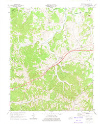
1973 Map of Gradyville
USGS Topo · Published 1974About this map
Gradyville and Milltown serve as the primary hubs in this mid-1970s landscape, where the northern border of Adair County meets Green County along the meandering course of Russell Creek. The area is defined by its rural settlement pattern, with small communities like Portland, Pickett, and Nell connected by winding roads and the prominent Parkway and Toll Road corridor. This survey reveals an active extraction economy, noting several Oil Field locations and significant Pipelines cutting across the terrain.
Find a feature on this map
51 named features on this map. Tap any name to fly to it.
Don’t see what you’re looking for? This feature index may not catch every label — zoom into the map to look around manually.
Map Details
Editions of this 1973 Gradyville Map
This is the sole edition of this map. No revisions or reprints were ever made.
Other maps of this area

1953 · Gradyville
USGS Topo · 1:24,000

1953 · Breeding
USGS Topo · 1:24,000

1953 · Edmonton
USGS Topo · 1:24,000

1953 · Amandaville
USGS Topo · 1:24,000

1953 · Exie
USGS Topo · 1:24,000

1953 · Gresham
USGS Topo · 1:24,000

1953 · East Fork
USGS Topo · 1:24,000

1953 · Cane Valley
USGS Topo · 1:24,000

1954 · Columbia
USGS Topo · 1:24,000

1956 · Corbin
USGS Topo · 1:250,000