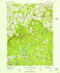
1954 Map of Grafton
USGS Topo · Published 1956About this map
Pittstown and the surrounding plateau terrain of Rensselaer County are defined here by a dense concentration of glacial lakes and mid-century reforestation efforts. The landscape is punctuated by numerous bodies of water, including the large Babcock Lake, Long Pond, and Dunham Res in the southwest corner. Significant portions of the central highlands are designated as a State Reforestation Area, indicating a transition in land use from earlier agricultural periods toward conservation and state-managed timber.
Find a feature on this map
42 named features on this map. Tap any name to fly to it.
Don’t see what you’re looking for? This feature index may not catch every label — zoom into the map to look around manually.
Map Details
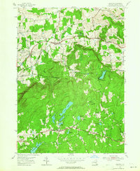
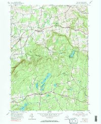
Editions of this 1954 Grafton Map
3 editions found
Other maps of this area

1888 · Berlin
USGS Topo · 1:62,500

1890 · Berlin
USGS Topo · 1:62,500

1893 · Cohoes
USGS Topo · 1:62,500

1893 · Troy
USGS Topo · 1:62,500

1894 · Berlin
USGS Topo · 1:62,500

1895 · Troy
USGS Topo · 1:62,500

1895 · Cohoes
USGS Topo · 1:62,500

1897 · Hoosick
USGS Topo · 1:62,500

1898 · Berlin
USGS Topo · 1:62,500

1898 · Cohoes
USGS Topo · 1:62,500