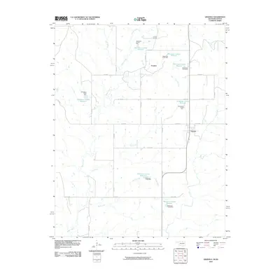
2010 Map of Grainola
USGS Topo · Published 2010About this map
Grainola and Frankfort anchor this portion of Osage County, Oklahoma, at the onset of the 21st century. The landscape is defined by its extensive drainage network and man-made water management features, including numerous numbered reservoirs like Oknoname 113141 Reservoir and Oknoname 113143 Reservoir. These basins are situated among the winding courses of Beaver Creek, Otter Creek, and Salt Creek. The local economy's ties to natural resources are evident in the northern section of the map at the Frankfort Oil Field, situated near the Kansas border. A dense grid of county roads, such as Co RD 4950 and Co RD 4804, provides access across the plains, connecting small settlements with the surrounding rangeland and the various dam sites that regulate the local watershed.
Find a feature on this map
44 named features on this map. Tap any name to fly to it.
Don’t see what you’re looking for? This feature index may not catch every label — zoom into the map to look around manually.
Map Details
Editions of this 2010 Grainola Map
This is the sole edition of this map. No revisions or reprints were ever made.
Other maps of this area

1889 · Burden
USGS Topo · 1:125,000

1916 · Foraker
USGS Topo · 1:62,500

1935 · Kaw
USGS Topo · 1:62,500

1955 · Wichita
USGS Topo · 1:250,000

1955 · Enid
USGS Topo · 1:250,000

1958 · Enid
USGS Topo · 1:250,000

1958 · Wichita
USGS Topo · 1:250,000
1962 · Cedar Vale West
USGS Topo · 1:24,000

1962 · Dexter SW
USGS Topo · 1:24,000

1964 · Kaw City
USGS Topo · 1:24,000