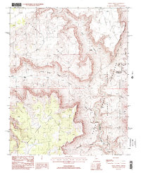
1988 Map of Grama Spring
USGS Topo · Published 1988About this map
Grama Spring and Willow Spring provide isolated water sources in this high-elevation landscape within the Kaibab National Forest. The geography is defined by deep, winding drainages including Grama Canyon, Hack Canyon, and Water Canyon, which cut through the high plateaus of Sunshine Point and Bulrush Point. This 1980s survey illustrates a region largely managed for conservation and wildlife, overlapping the Grand Canyon National Game Preserve and the Kanab Creek Wilderness. A single Prospect in the northern reaches and scattered 4WD tracks suggest the limited historical mining and transport activity in this corner of Mohave County. The map also captures the Mohave and Coconino county line as it traverses the drainages leading toward the Grand Canyon.
Find a feature on this map
19 named features on this map. Tap any name to fly to it.
Don’t see what you’re looking for? This feature index may not catch every label — zoom into the map to look around manually.
Map Details
Editions of this 1988 Grama Spring Map
2 editions found
Other maps of this area

1886 · Kaibab
USGS Topo · 1:250,000

1953 · Grand Canyon
USGS Topo · 1:250,000

1954 · Heaton Knolls SE
USGS Topo · 1:24,000

1954 · Heaton Knolls
USGS Topo · 1:62,500

1957 · Grand Canyon
USGS Topo · 1:250,000

1957 · Jumpup Canyon
USGS Topo · 1:62,500

1958 · Grand Canyon
USGS Topo · 1:250,000

1960 · Grand Canyon
USGS Topo · 1:250,000

1962 · Kanab Point
USGS Topo · 1:62,500

1962 · Tuckup Canyon
USGS Topo · 1:62,500