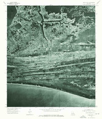
1975 Map of Grand Bayou
USGS Topo · Published 1976About this map
The salt marshes and coastal ridges of Cameron Parish are captured in this 1975 orthophotograph, providing a detailed visual of the Louisiana shoreline before significant modern coastal erosion. This imagery highlights the intricate drainage patterns where Grand Bayou snakes through the wetlands, eventually connecting toward the eastern edge of Calcasieu Lake. The southern boundary is defined by the sweeping coastline of the Gulf of Mexico, separated from the inland marshes by a series of distinct parallel ridges. These linear landforms, characteristic of the chenier plain, show the complex geography of the region as it transitioned from open water to marshland over centuries. The map's photographic detail allows for the study of field patterns, oil and gas infrastructure, and early coastal access roads that were present during the mid-1970s.
Find a feature on this map
3 named features on this map. Tap any name to fly to it.
Don’t see what you’re looking for? This feature index may not catch every label — zoom into the map to look around manually.
Map Details
Editions of this 1975 Grand Bayou Map
This is the sole edition of this map. No revisions or reprints were ever made.
Other maps of this area

1934 · Cameron
USGS Topo · 1:24,000

1934 · Sweet Lake
USGS Topo · 1:24,000

1934 · Grand Bayou
USGS Topo · 1:24,000

1934 · Boudreaux Lake
USGS Topo · 1:24,000

1935 · Cameron
USGS Topo · 1:31,680

1935 · Sweet Lake
USGS Topo · 1:31,680

1935 · Hackberry
USGS Topo · 1:31,680

1935 · Boudreaux Lake
USGS Topo · 1:31,680

1935 · Grand Bayou
USGS Topo · 1:31,680

1935 · Bay Labauve
USGS Topo · 1:31,680