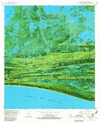
1982 Map of Grand Bayou
USGS Topo · Published 1982About this map
Sabine National Wildlife Refuge dominates the northern reaches of this coastal landscape, where the Grand Bayou and its sprawling prongs—including North Prong, South Prong, and East Prong—filter through the marsh toward Calcasieu Lake. The southern edge of the sheet is defined by the chenier ridges of Front Ridge and Mesquite Ridge, which provided the high ground necessary for settlement along the Gulf of Mexico.
Find a feature on this map
31 named features on this map. Tap any name to fly to it.
Don’t see what you’re looking for? This feature index may not catch every label — zoom into the map to look around manually.
Map Details
Editions of this 1982 Grand Bayou Map
This is the sole edition of this map. No revisions or reprints were ever made.
Other maps of this area

1934 · Cameron
USGS Topo · 1:24,000

1934 · Sweet Lake
USGS Topo · 1:24,000

1934 · Grand Bayou
USGS Topo · 1:24,000

1934 · Boudreaux Lake
USGS Topo · 1:24,000

1935 · Cameron
USGS Topo · 1:31,680

1935 · Sweet Lake
USGS Topo · 1:31,680

1935 · Hackberry
USGS Topo · 1:31,680

1935 · Boudreaux Lake
USGS Topo · 1:31,680

1935 · Grand Bayou
USGS Topo · 1:31,680

1935 · Bay Labauve
USGS Topo · 1:31,680