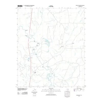
2010 Map of Grand Bluff
USGS Topo · Published 2010About this map
The Sabine River dominates this Panola County landscape, carving a winding path marked by specific riverine landmarks like Shoemaker Bluff, West Camp Bend, and Twin Rock. This area of East Texas exhibits a complex network of wetlands and backwaters, including Wattle Duck Pond, Alligator Lake, and Jernigan Lake, which suggest a terrain defined by seasonal flooding and shifting watercourses. The local economy and land use are anchored by the Carthage Gas Field and small settlements like Grand Bluff and Horton. For those researching local history, the map provides precise locations for the Grand Bluff Cemetery and Crossroads Cemetery, alongside distinctive fishing and river spots such as Baker Fish Hole, Black Shoals, and Reed Hole. This detailed view captures the rural character of the region as it appeared in the early 21st century, where industrial gas extraction exists alongside traditional river-bottom geography.
Find a feature on this map
42 named features on this map. Tap any name to fly to it.
Don’t see what you’re looking for? This feature index may not catch every label — zoom into the map to look around manually.
Map Details
Editions of this 2010 Grand Bluff Map
This is the sole edition of this map. No revisions or reprints were ever made.
Other maps of this area

1943 · Waskom
USGS Topo · 1:62,500

1945 · Waskom
USGS Topo · 1:62,500

1945 · Socagee Bayou
USGS Topo · 1:62,500

1956 · Tyler
USGS Topo · 1:250,000

1956 · Deadwood
USGS Topo · 1:62,500

1958 · Darco
USGS Topo · 1:62,500

1958 · Carthage
USGS Topo · 1:62,500

1962 · Stricklin Springs
USGS Topo · 1:24,000

1962 · De Berry
USGS Topo · 1:24,000

1983 · Grand Bluff
USGS Topo · 1:24,000