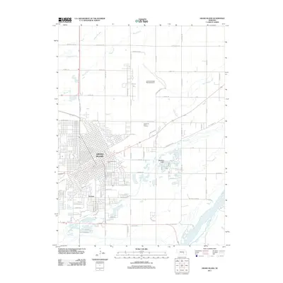
2011 Map of Grand Island
USGS Topo · Published 2011About this map
Grand Island and the neighboring community of Parkview are shown here during a period of modern expansion along the Platte River valley. The landscape is defined by the complex water systems of the Platte and the Wood River, which feed several recreational water bodies including Kuesters Lake, Crystal Lake, and L E Ray Lake. This 2011 survey highlights the dense grid of the city center, including the Grand Island Post Office, alongside the significant infrastructure of the Central Nebraska Regional Airport and the horse racing facilities at Fonner Park.
Find a feature on this map
47 named features on this map. Tap any name to fly to it.
Don’t see what you’re looking for? This feature index may not catch every label — zoom into the map to look around manually.
Map Details
Editions of this 2011 Grand Island Map
This is the sole edition of this map. No revisions or reprints were ever made.
Other maps of this area

1892 · Grand Island
USGS Topo · 1:62,500

1895 · Grand Island
USGS Topo · 1:62,500

1898 · Grand Island
USGS Topo · 1:125,000

1899 · St. Paul
USGS Topo · 1:125,000

1955 · Broken Bow
USGS Topo · 1:250,000

1955 · Grand Island
USGS Topo · 1:250,000

1956 · Broken Bow
USGS Topo · 1:250,000

1957 · Grand Island
USGS Topo · 1:250,000

1958 · Grand Island
USGS Topo · 1:250,000
1961 · St. Paul SW
USGS Topo · 1:24,000
Featured Places
- Grand Island, NE
- Kuesters Lake, NE
- Kingwood Estates, Grand Island
- Parkview, Grand Island
- Pioneer Estates, Grand Island