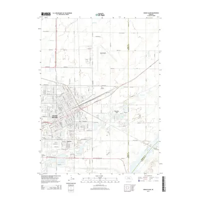
2014 Map of Grand Island
USGS Topo · Published 2014About this map
Grand Island serves as the focal point of this 2014 survey, illustrating the dense urban grid and surrounding expansion of this Nebraska hub. The landscape is defined by the proximity of the Platte River and the meandering path of the Wood River, which cuts through the southern residential areas near Parkview. Civic and educational infrastructure is prominent, including the sprawling campus of Central Community Coll and the extensive grounds of the Central Nebraska Regional Airport.
Find a feature on this map
88 named features on this map. Tap any name to fly to it.
Don’t see what you’re looking for? This feature index may not catch every label — zoom into the map to look around manually.
Map Details
Editions of this 2014 Grand Island Map
This is the sole edition of this map. No revisions or reprints were ever made.
Other maps of this area

1892 · Grand Island
USGS Topo · 1:62,500

1895 · Grand Island
USGS Topo · 1:62,500

1898 · Grand Island
USGS Topo · 1:125,000

1899 · St. Paul
USGS Topo · 1:125,000

1955 · Broken Bow
USGS Topo · 1:250,000

1955 · Grand Island
USGS Topo · 1:250,000

1956 · Broken Bow
USGS Topo · 1:250,000

1957 · Grand Island
USGS Topo · 1:250,000

1958 · Grand Island
USGS Topo · 1:250,000
1961 · St. Paul SW
USGS Topo · 1:24,000
Featured Places
- Grand Island, NE
- Kuesters Lake, NE
- Kingwood Estates, Grand Island
- Parkview, Grand Island
- Pioneer Estates, Grand Island