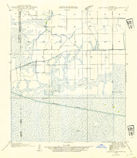
1954 Map of Grand Lake East NE
USGS Topo · Published 1954About this map
The Intracoastal Waterway cuts a straight, engineered path across the southern marshland of this Vermilion Parish landscape. This 1954 edition, based on field examinations from 1932 and aerial photography from the Air Corps, shows a transition from structured agricultural drainage to the open wetlands of the Louisiana coast. In the north, the Gueydan Cem and State Highway No 518 mark the edge of upland settlement, while a network of canals including the Gueydan Canal, Spencer Canal, and Florence Canal facilitate movement through the basin. Near the center of the sheet, Florence and the Florence Hunt Club serve as remote outposts amid the tidal landscape of Bayou L'Orange. Natural features like Deer Island and Salt Ridge rise slightly above the surrounding marsh, providing key landmarks for navigation and local history.
Find a feature on this map
12 named features on this map. Tap any name to fly to it.
Don’t see what you’re looking for? This feature index may not catch every label — zoom into the map to look around manually.
Map Details
Editions of this 1954 Grand Lake East NE Map
This is the sole edition of this map. No revisions or reprints were ever made.
Other maps of this area

1946 · Morse
USGS Topo · 1:31,680

1946 · Lake Arthur
USGS Topo · 1:31,680

1946 · Schooner Bayou NW
USGS Topo · 1:31,680

1946 · Schooner Bayou SW
USGS Topo · 1:31,680

1949 · Gueydan
USGS Topo · 1:31,680

1952 · Lake Charles
USGS Topo · 1:250,000

1953 · Jacks Point Island
USGS Topo · 1:24,000

1954 · Grand Lake East NW
USGS Topo · 1:31,680

1954 · Grand Lake East SE
USGS Topo · 1:31,680
1954 · Grand Lake East SW
USGS Topo · 1:31,680