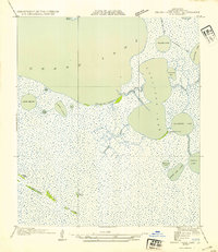
1954 Map of Grand Lake East SW
USGS Topo · Published 1954About this map
Stienberg Fur Co Camp stands as a rare human outpost on the southeastern shore of Cullicon Lake, reflecting the commercial trapping history of Cameron Parish in the 1930s. The landscape is dominated by a complex network of coastal wetlands and ridges, most notably the Chenier Du Fond, which provides a natural levee between the vast open water of Grand Lake and the marshy interior. Navigational history is etched into the terrain via the Old Intracoastal Waterway, which cuts through the center of the sheet near the small settlement of Price.
Find a feature on this map
29 named features on this map. Tap any name to fly to it.
Don’t see what you’re looking for? This feature index may not catch every label — zoom into the map to look around manually.
Map Details
Editions of this 1954 Grand Lake East SW Map
This is the sole edition of this map. No revisions or reprints were ever made.
Other maps of this area

1932 · Constance Bayou NE
USGS Topo · 1:31,680

1932 · Constance Bayou NW
USGS Topo · 1:31,680

1934 · Catfish Lake
USGS Topo · 1:24,000

1934 · Latania Lake
USGS Topo · 1:24,000

1935 · Catfish Lake
USGS Topo · 1:31,680

1935 · Latania Lake
USGS Topo · 1:31,680

1946 · Hog Bayou NE
USGS Topo · 1:31,680

1949 · Hog Bayou NE
USGS Topo · 1:31,680

1954 · Grand Lake East NW
USGS Topo · 1:31,680

1954 · Grand Lake East SE
USGS Topo · 1:31,680