
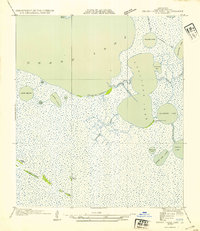
1954 Map of Grand Lake East NW
USGS Topo · Published 1954About this map
Mallard Bay and Umbrella Bay dominate this low-lying coastal landscape, which was surveyed in detail in the early 1930s. The marshy terrain is punctuated by slightly elevated features like Gum Tree Ridge and Flat Prairie Ridge, providing crucial topographical variation in an area otherwise defined by water and wetlands. Human activity in this remote Cameron Parish region is centered on the Intracoastal Waterway and various irrigation or transit channels such as the Gueydan Canal and Lattanier Ditch.
Find a feature on this map
27 named features on this map. Tap any name to fly to it.
Don’t see what you’re looking for? This feature index may not catch every label — zoom into the map to look around manually.
Map Details
Editions of this 1954 Grand Lake East NW Map
This is the sole edition of this map. No revisions or reprints were ever made.
Other maps of this area

1934 · Catfish Lake
USGS Topo · 1:24,000

1934 · Latania Lake
USGS Topo · 1:24,000

1935 · Catfish Lake
USGS Topo · 1:31,680

1935 · Latania Lake
USGS Topo · 1:31,680

1946 · Lake Arthur
USGS Topo · 1:31,680

1947 · Thornwell
USGS Topo · 1:31,680

1949 · Gueydan
USGS Topo · 1:31,680

1952 · Lake Charles
USGS Topo · 1:250,000

1954 · Grand Lake East SE
USGS Topo · 1:31,680
1954 · Grand Lake East SW
USGS Topo · 1:31,680